I finished manually digitizing Omaha’s Keystone Trail using Google Earth and creating a path, by eyeball, for the entire distance, in numerous segments to avoid mistakes while in Google Earth. I then manually edited the .KML file to merge the segments and correct some minor errors, and then converted the <coordinates>…</coordinates> to a Garmin Mapsource tracklog. This resulting in a track that had 2412 points (whew, what a tedious effort) for a total distance of 40.9km (my previous estimate by manually creating a Mapsource route overlaid on my tracklogs resulted in 40.7km which is probably less accurate than the track created in Google Earth, but at least they’re close).
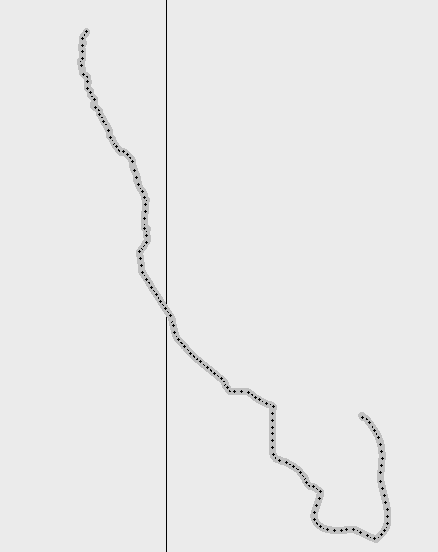
I completed another 11.1 mile ride today on the northern segment (including a flat tire that forced me to turn around) and so have 12 total tracklogs for a combined distance of 128.5km or 3.14X coverage. So here’s the complete trace:
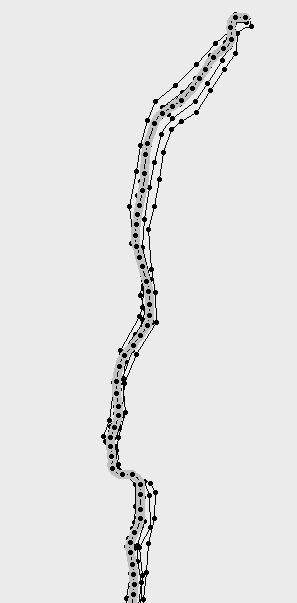
The northern portion of the trail is the most problematic for getting an accurate trace. Here is the first mile or so:
The grey trace is the one I made from Google Earth and the others are actual tracklogs of walks or rides. The problem is this portion of the trail goes through a park and is heavily wooded. This makes digitizing on Google Earth difficult as the trail is often not visible. But the real tracklogs are problematic too as GPS doesn’t work as well (accurately) in woods since the trees and leaves scatter or attenuate the satellite signal. Here’s the real difficulty shown zoomed in some:
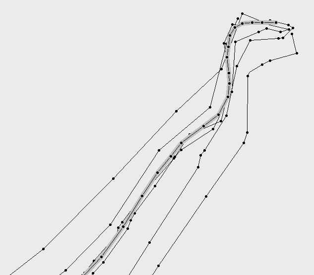
This is the very start of the trail, mostly under trees. There is a parking lot and a small playground (the northernmost curve goes around that playground, is visible in Google Earth so the grey trace is probably the most accurate). But soon the entire trail is under tree canopy so you can see the huge spread (over 60m wide from most extreme tracks). It’s interesting that today’s ride (out-and-back in this area twice) is actually what is creating the outlying tracks and the walk I took a few days ago is much closer to the Google Earth tracing, so this shows how more data does not improve the accuracy even though eyeball averaging of the outlying tracks would probably be close to the Google Earth trace.
And this curve:
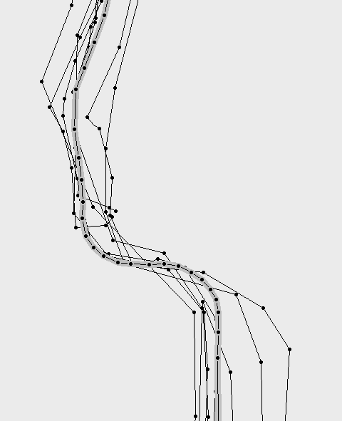
where the trail is (mostly) visible in Google Earth and thus the grey track is probably the most accurate again shows the problem of GPS logs significantly deviating from the true path.
So with more data I don’t actually have a better answer leaving two questions: 1) how much more data will it take to really define better accuracy, say at least 2m, and, 2) what kind of algorithm will it take to actually do the averaging.
Again, as I’ve said before, this exercise is just practice as getting precise location of the Keystone is fairly irrelevant, but going through the exercise provides the opportunity to work through the problem and develop technique (or at least some sense of accuracy) for someday charting some trail that is not well known.
About dmill96
old fat guy, who used to create software in Silicon Valley (almost even before it was called that), who used to go backpacking and bicycling and cross-country skiing and now drives AWD in Wyoming, takes pictures, studies Spanish and writes long blog posts and does xizquvjyk.


Tracing just the Keystone
I finished manually digitizing Omaha’s Keystone Trail using Google Earth and creating a path, by eyeball, for the entire distance, in numerous segments to avoid mistakes while in Google Earth. I then manually edited the .KML file to merge the segments and correct some minor errors, and then converted the <coordinates>…</coordinates> to a Garmin Mapsource tracklog. This resulting in a track that had 2412 points (whew, what a tedious effort) for a total distance of 40.9km (my previous estimate by manually creating a Mapsource route overlaid on my tracklogs resulted in 40.7km which is probably less accurate than the track created in Google Earth, but at least they’re close).
I completed another 11.1 mile ride today on the northern segment (including a flat tire that forced me to turn around) and so have 12 total tracklogs for a combined distance of 128.5km or 3.14X coverage. So here’s the complete trace:
The northern portion of the trail is the most problematic for getting an accurate trace. Here is the first mile or so:
The grey trace is the one I made from Google Earth and the others are actual tracklogs of walks or rides. The problem is this portion of the trail goes through a park and is heavily wooded. This makes digitizing on Google Earth difficult as the trail is often not visible. But the real tracklogs are problematic too as GPS doesn’t work as well (accurately) in woods since the trees and leaves scatter or attenuate the satellite signal. Here’s the real difficulty shown zoomed in some:
This is the very start of the trail, mostly under trees. There is a parking lot and a small playground (the northernmost curve goes around that playground, is visible in Google Earth so the grey trace is probably the most accurate). But soon the entire trail is under tree canopy so you can see the huge spread (over 60m wide from most extreme tracks). It’s interesting that today’s ride (out-and-back in this area twice) is actually what is creating the outlying tracks and the walk I took a few days ago is much closer to the Google Earth tracing, so this shows how more data does not improve the accuracy even though eyeball averaging of the outlying tracks would probably be close to the Google Earth trace.
And this curve:
where the trail is (mostly) visible in Google Earth and thus the grey track is probably the most accurate again shows the problem of GPS logs significantly deviating from the true path.
So with more data I don’t actually have a better answer leaving two questions: 1) how much more data will it take to really define better accuracy, say at least 2m, and, 2) what kind of algorithm will it take to actually do the averaging.
Again, as I’ve said before, this exercise is just practice as getting precise location of the Keystone is fairly irrelevant, but going through the exercise provides the opportunity to work through the problem and develop technique (or at least some sense of accuracy) for someday charting some trail that is not well known.
Rate this:
Share this:
Related
About dmill96
old fat guy, who used to create software in Silicon Valley (almost even before it was called that), who used to go backpacking and bicycling and cross-country skiing and now drives AWD in Wyoming, takes pictures, studies Spanish and writes long blog posts and does xizquvjyk.